Maps
The Mountaineers archive contains an extensive collection of maps available as a reference resource for members and researchers. All maps are housed in the large map cabinet currently located in the basement storage room. The collection leans heavily toward the Pacific Northwest but includes maps from a number of other mountainous areas throughout the world. It was actively maintained as part of the library through the 1990s when only printed maps were available and were relatively expensive. The availability of excellent maps on GPS units, desktop computers and mobile devices has made it impractical and unnecessary for the Mountaineers to maintain an up-to-date printed map collection.
The most frequently used maps for hikers and climbers has always been the the excellent set of USGS topographical maps covering all of the United States, usually down to the 1:24,000 Quad scale. All of these maps, both current and historical, are available online at The National Map, a site with an abundance of other mapping resources. This User Guide is a good place to start to access these maps.
In the Northwest, Green Trails and Custom Correct maps are popular with hikers because they highlight maintained trails and have been updated more frequently than the USGS topos. The map collection includes nearly a full set of older versions of these maps which can be interesting for researchers investigating the state of the trail system as it was when each map was published. Current versions of Green Trails and Custom Correct maps are not being added to the collection, but we would welcome donations of maps in good condition.
A number of custom maps have been created over the years to fill the gap between local knowledge and official maps.
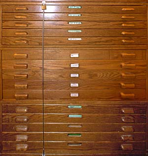
Summary of map cabinet contents
| Drawer | Description |
|---|---|
| 1 | Washington State USGS topographic 15' (1:50,000) |
| 2 | Washington State USGS topographic 7.5' (1:24,000) A-L |
| 3 | Washington State USGS topographic 7.5' (1:24,000) M-Z |
| 4 | Green Trails, Custom Correct, National Parks, National Forest & Wilderness Areas |
| 5 | Washington Miscellaneous maps |
| 6 | Washington large size maps |
| 7 | Canadian Maps, mostly west coast provinces |
| 8 | Europe (Alps), Mexico, South America (Andes) |
| 9 | Asia (Himalaya), Africa, New Zealand, Antarctica |
| 10 | Alaska maps |
| 11 | Idaho and Oregon maps |
| 12 | California maps |
| 13 | Miscellaneous 1 |
| 14 | Miscellaneous 2 |
| 15 | Miscellaneous 3 |