These maps have been created over the years to capture local knowledge that was not available in government or commercial maps. Click on a map for a high resolution image.
...
1949 Mountaineers Summer Outing map
The 1949 summer outing began with a camp at the Trinity Mine in the upper Chiwawa River valley. From there camps were made at Buck Creek Pass, Image Lake, and Lyman Lake. At that time there was no trail over Spider Gap so the group split with the "backtrackers" heading back over Buck Creek Pass with the pack animals and the "backpackers" continuing on to Spider Meadows and a camp at Leroy Creek. Climbing activities included Glacier Peak, a spectacular rock climb of Sitting Bull, and a beautiful day on Chiwawa Mountain. A humorous "Report to the Sock Holders" by Ellen Wash can be found in the 1949 Mountaineers Annual. |
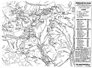
1952 Snoqualmie Pass Map
Snoqualmie Pass Region showing trails & routes for "valley pounder" & "peak bagger" by H. R. Morgan, July 1952 Some notable features on this map:
|
...
- KM - Miscellaneous
- KA - Alpine Lakes
- KN - North (Lake Chelan, Ross Lake, Pasayten, Baker)
- KC - Central (Foothills, Mountain Loop, Icicle Creek, Stevens Pass)
- KS - South (Rainier, Adams, Goat Rocks, St Helens)
- KO - Olympics


