You are viewing an old version of this page. View the current version.
Compare with Current
View Page History
« Previous
Version 4
Next »
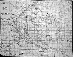
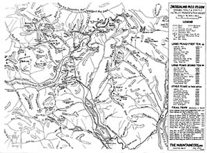
These maps have been created over the years to capture local knowledge that was not available in government or commercial maps. Click on a map for a high resolution image.
 | Map included in the materials for the 1925 Summer Outing from Snoqualmie Pass to Mount Stuart. |
1931 Snoqualmie Pass Map
 | Drawn from USFS and USGS maps by H. V. Strandberg & H. R. Morgan, November 1931 Some notable features on this map: - Alaska Lake was called Lake Gingerless
- Lots of trail routes in Commonwealth Basin up to Lundin, Red and Kendall
- The west tunnel entrance at Rockdale shows several structures
- Mountaineers Snoqualmie Lodge by Lodge Lake, with trail straight up from the highway
- Trail directly up ridge west of Rocky Run (since destroyed by logging)
- Rampart Lakes not noted
- "The Dome" by Snoqualmie Mountain is named
- Bryant Peak is very close to Chair. Current Bryant Peak is where Hemlock Peak is on this map
- Snow Lake trail goes by Source Lake
- Trail down the Pratt Valley is west of the river, not along the future RR grade east of the river.
- The Tooth is accessed from the Denny Creek side
- Wright Mountain is attached to a subpeak of Roosevelt, not to the high point north of Gem Lake where it is now.
|
1952 Snoqualmie Pass Map
 | Snoqualmie Pass Region showing trails & routes for "valley pointer" & "peak bagger" by H. R. Morgan, July 1952 Some notable features on this map: - Mountaineers lodge appears
- Sunset Highway shown, predating I-90
- The railroad line and stations are still shown
- LeanTo at Camp Lookout on the Pratt Lake trail
- No logging roads shown in the South Fork valley or around Mt Margaret
- A trail goes past Kaleetan Lake and over the ridge to near Lake Caroline
- Rock Creek and Goat Creek trails are shown with equal prominence
- Lots of trails are shown in the Gold Creek valley most of which are now overgrown
- Pratt Valley trail connects to the lake, now badly overgrown
- Mineral Mountain was still in transition to being called it's current name of Three Queens
|


