...
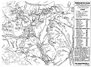
Snoqualmie Pass Region showing trails & routes for "valley pointer" & "peak bagger" by H. R. Morgan, July 1952 Some notable features on this map:
|
1959 Pete Steele maps
Born in Tacoma in 1922, Pete Steele moved to Seattle as an infant. He attended school there and graduated from the University of Washington. During World War II he was a photographer in the Air Force in both the European and Pacific area. He returned to Seattle where he resided until coming to Ardenvoir in 1961 where he was a watchman at the mill. Pete was troubled by the pace of logging in the high country in the 1950s and 60s. He hiked extensively and produced two maps under the label "Washington Mountain Maps" which show a remarkable knowledge of the area at the time. An index map makes it clear that he had ambitions to produce many more such maps, but these are the only two that he completed and are reproduced here with permission from his sister. Pete died at age 54 in 1976.
...
